
Each fall on our migration south we take a detour though the IntraCoastal Waterway (ICW) to avoid needing the “thread the needle” around Cape Hatterus which is knows as the graveyard of ships since you need to be far enough offshore to avoid the shallow water which goes MILES offshore but not so far offshore that you enter the Gulf Stream which often kicks up deadly dangerous waves.
Hampton VA
We start our ICW detour in Hampton, Virginia, near Norfolk, VA. There are several palaces to anchor but we prefer the one near Fort Monroe. There is good holding and relatively good protection from wind and waves. There is also a very convenient dinghy dock with easy access to a grocery store and other services, several bookstores, and good restaurants.

The anchorage is so convenient that we’ve spent weeks here, especially on the trip north, waiting for good weather to run up Maryland and New Jersey.
Chesapeake VA – Free Dock
On our runs south, our first hop is a very easy morning down to the “Great Bridge Lock” and the Free Dock at the “Great Bridge Bridge” (yes, you really do need to double up the word bridge to differentiate the bridge from the lock since they use the same VHF Channel 13.

The run is simple with just Gilmerton Bridge, which opens on demand (they listen to VHF 13) outside of rush hour traffic. So they stay closed from 6:30 a.m. to 8:30 a.m. and from 3:30 p.m. to 5:30 p.m., Monday through Friday which has never been a problem for us.
Then there is the “Great Bridge Lock” which opens 20 minutes after the hour and will try to fit everyone on the southern side of the lock which has great rubber bumpers. We still drop fenders on both sides just to be safe and have never had an issue. The water height difference isn’t much, just a few feet. A bow line tossed to the handler and a stern line both of which get looped around a cleat and sent back for someone on the boat to either ease out (the way south) or take in (the way north). The whole process is quite quick. Just about 15 minutes from closing to opening the lock. The wait is just waiting for everyone to get set up.
The Lock coordinates with the “Great Bridge Bridge” so when you are let through the bridge will be just about ready to open. (Note: while the bridge typically opens every hour in 2025 an issue has the bridge only opening on even hours. So 6am 8am, 10am etc.)
There are two free docks, one on either side of the bridge. We tend to try for the initial side we’re on so we don’t get stuck on a side without space. The southern side in between the bridge and lock, and then the northern side on the other side of the bridge.

The dock is free to use for 48 hours and we usually stay the whole time to make the most of the convenience. Walking distance to a grocery store, a laundromat, and a gas station that has Gas, Diesel, and Propane. With the dock and the risk of dragging anchor mitigated, it’s also a convenient spot to call for an UBER to go to the larger stores nearby. There is no water or power at either of the docks, but each has a good dumpster to get rid of trash, and the building on the southern side has a water spigot that works, and we’ve used it to top off our tanks with a few trips with a 5-gallon water jug.
The North River
After our stay in Chesapeake, we make our way south again to find a good spot to anchor in the North River. There is room for 1,000 boats in the North River, but we have two spots we typically stop at, depending on which way the wind is blowing. The day is a bit longer; it usually takes us about 10 hours, and there are two bridges past the Great Bridge that you’ll need to call. The Centerville Bridge and The North Landing Bridge. Both monitor VHF 13, and for speedy boats, you can get through without much of a wait. They open every half hour, and unfortunately, it takes us about 40 minutes to get from one to the other, so there is almost always a wait. That and the very narrow channel just north of Coinjock are the only real issues with this run.

There isn’t really anything in the North River; it’s pretty isolated, and there is only one spot to go to shore. If you’re lucky enough to have wind from the east (or no wind) then you can anchor close to the “secret canal” (named by the children). The canal runs to the small town of Grandy, specifically to a private marina with no trespassing signs in a private neighborhood that includes a private golf course. We’ve only gone in once, it was interesting and we hadn’t seen the signs until we were leaving. But with a dog who may need to go to shore there are a few spots along the canal before you get to the private area that could be suitable.

But anchoring is simple enough. With 10 feet of depth just about everywhere all you need to do is pick a side and then go far enough off the channel to where you won’t be in the way or close enough to shore that you’ll have protection from the wind.

The Alligator River
The next day is another long one to run from the North River to the Alligator River. But it’s a welcome day since we are almost always able to pull out the sails and get a wind powered boost.
There is only one bridge and only for a little longer. The Alligator River Bridge on the northern part of the Alligator River is being replaced with a fixed bridge. I think I read late 2026, but for now, the bridge opens on demand but won’t open if the wind gusts are 35-knots or more. That said, there is usually a wait since this is a bottleneck, and the bridge operator will make folks wait till there is a small group. The wait usually isn’t very long. The biggest difference about this bridge is that they will ask for your Federal Documentation Number or your State Registration Number. I suspect this has to do with funding for the fixed bridge and getting accurate counts.
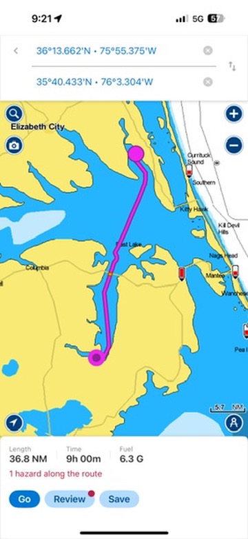
There really is nothing along the Alligator River. And as you get near the southern part where it turns west you’ll loose cell reception and finally get some quiet!
Our prefered anchorage is just after the turn west. We like to anchor off the channel across from Deep Point which we’ve found offers better wind protection. We’ve spent four days in the “Deep Point” anchorage in wind over 30 knots and had no fetch or dragging.
Bellhaven NC
After a night in the Alligator River, hopefully with a New Moon and clear sky so you can really see the stars, we move to Bellhaven NC. Another huge anchorage and another practical stop.

The canal can get tedious at times since it’s so long and straight but it’s an easy run with no bridges to call and no depth issues. Once on the other side of the canal there is an opportunity to pull out the sails again and get some sailing in on the way to Belhaven.

The anchorage is huge, and most folks will anchor close to the town’s dinghy dock across from the Belhaven Marina. We don’t we push all the way down past the town’s free dock and anchor much closer to the bridge for a couple of reasons.
The ride to the dinghy dock for water and the hardware store isn’t too long. And there isn’t much “downtown”.
The dinghy ride to the town’s free dock gives you the shortest walk to the grocery store although it comes with a climb up “the ladder of doom” so we tend to beach the dinghy at the boat launch for grocery runs for the “almost” shortest walk. We also tend to pick up more diesel when in Belhaven and will beach the dinghy by the boat launch and walk across the street to a gas station that is often significantly cheaper than the marina.
Another reason we like to anchor closer to the bridge is there are fewer (sometimes zero) other boats there so there is less worry about someone dragging into us.
Oriental NC
Our next hop is another easy run but there are some parts where it’s important to watch the charts and stay in the channel. Specifically after crossing the Pamlico River and entering Goose Creek. We may have run aground this fall there. Not fun, we’d been blown out of the channel and I wasn’t paying as much attention as I should have been.

Oriental is another great stop. When going south we’ll wait in Oriental until there is good weather to head out of the ICW at Beaufort NC and sail all the way down to Cape Fear overnight. If you leave Oriental in the morning, it’s only a six hour run till you are exiting the harbor and heading for open ocean. We try to leave at 8am or 9am so we are leaving with plenty of sunlight to get offshore before dark.
This means we’re often in Oriental for a week or more. We try to anchor “inside” the main harbor just off the Oriental Harbor Marina. The area has room for a few boats and while tight is a popular spot. We try to get in there since we’re usually waiting for the weather to avoid needing to go to the more crouded anchorage at Beaufort NC. There is surprising depth in the inner harbor.
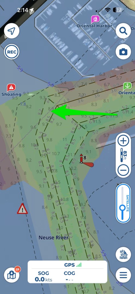
If there isn’t room in the inner harbor there is lots of room in the outer harbor outside of the breakwater. The only downside is that there can be a bit of fetch when the wind picks up.

Oriental is a very practical stop. They have several free docks, a pumpout at one of the free docks, a great grocery store that will pick you up and drop you back off at any of the docks in town, a great chandlery, and a great cafe where the topic of conversation is almost always sailing related.

Great info and details … Thanks for sharing 🙏
LikeLike